
 Italiano



Introduction
The increasing use of GPS-enabled devices, particularly cycle computers and smartphone applications, has created a valuable new source of information for collision reconstruction. GPS data can provide insights into rider behaviour in the lead up to a collision. This type of data can provide speed and positional information, whilst also illustrating an individual’s typical activity patterns, such as regular routes, usual times of day, and overall duration or distance. When seeking to understand liability and causation, this type of data can be crucial.
Moreover, it can support comparative analysis, for example by showing how other users have travelled along the same path or stretch of road, or by evidencing changes in a person’s activity profile before and after a collision, including frequency, duration, distance and speed. For a court, this kind of insight can be highly valuable as it may assist in assessing how an “ordinary” person behaves in a similar environment.
In its simplest form, GPS data obtained from cycle computers and wearables consists of a series of location points, commonly recorded at one sample per second (1 Hz) in sports activity applications. Platforms such as Strava are extremely popular in the health and fitness space. The availability of this kind of data is therefore becoming more prevalent. Wearable devices, such as smart watches and activity trackers are now commonly owned, contributing further to the volume of available data. However, not all GPS-derived data is equal.
Many people subscribe to the familiar phrase, “If it’s not on Strava, it didn’t happen.” In practice, however, even Strava does not always show exactly what occurred. Differences between platform outputs are not uncommon. Often, the investigator’s initial task is to understand the distinction between what is displayed on the platform, what the exported data indicates, and what actually happened, an important consideration when assessing evidential reliability.
As with other forms of digital data, on the surface the data appears straightforward and simple to interpret. In reality, uncertainties arising from the way GPS data is captured, and how those uncertainties are addressed introduce significant complexity. This article sets out three tiers of data and their implications for forensic analysis.
The Activity View: Interpreted & Processed Data
The activity page on websites such as Strava presents a user-friendly visualisation of an activity, including route mapping, speed, elevation, and segment efforts. However, this view represents processed rather than raw data. When an activity is uploaded, Strava parses the incoming file and independently recalculates metrics such as distance and speed (Strava, 2026a).
As a result:
- Displayed speed and distance may differ from the recording device
- Data may be resampled, averaged, or normalised
- Graphs often reflect smoothed or reconstructed values
From a collision reconstruction perspective, this creates an important limitation: website interfaces are an interpretation layer rather than a primary data source. This layer is designed with consumers in mind, and is often processed to be both visually appealing and to allow users to easily interpret it. While minor uncertainty or processing errors may be acceptable for recreational used, they may be critical in litigation. It is therefore generally unsuitable as the sole evidential basis, particularly where second-by-second dynamics, such as braking, sudden deceleration or sudden acceleration, are under scrutiny.
Getting The Most Accurate Data
Many of these websites allow users to export activities as GPX (Global Positioning XML) files. These are widely used because of their compatibility and readability. However, GPX files exported from some platforms, including Strava, represent a reduced dataset (Strava, 2026b). These exports typically contain time-stamped location data and limited sensor information but do not retain the full-range, original sensor streams. Moreover, their distance calculations between sequential points may require recalculation. Over greater distances, the data tends to be fairly accurate, but over shorter distances – which are often most relevant in collision reconstruction – errors may become more pronounced and must be accounted for. In evidential terms, these types of exported files are often used as secondary data: useful for mapping and general movement analysis, but limited in precision.
GPS measurements are inherently subject to error, often varying by several metres even under good conditions. To improve usability for consumers, platforms and devices often apply filtering and smoothing algorithms. While these processes improve visual clarity, they can obscure short-duration events that may be critical in a collision scenario. In simplified data sets (GPX files for example), speed is reconstructed from positional change and can amplify noise potentially resulting in sporadic speed values being displayed.
The most complete and forensically valuable dataset is the original activity file, typically in FIT (Flexible and Interoperable Data Transfer) format. Garmin’s documentation confirms that the format is designed to store rich, multi-parameter activity data at high fidelity (Garmin, n.d.). Strava, for example, recommends exporting the original activity file where possible (Strava, 2026b). FIT files are designed specifically for performance and sensor recording and may contain:
- High-resolution timestamped GPS data
- Recorded speed (not just derived speed)
- Distance streams (e.g. wheel-based measurements)
- Sensor inputs (power, cadence, heart rate)
- Device metadata and recording intervals
- Event markers (pauses, laps, etc.)
A key distinction is that FIT files often contain several independent measurements of movement, whereas a GPX file is typically limited to positional data . Having the most accurate and reliable data allows collision investigators to cross validate between data sources, identify anomalies or signal loss, and obtain more accurate speed and positional data. Whilst this data is also subject to the general uncertainty of any GPS device, having access to a wider range of inputs allows for independent processing and a more accurate assessment of uncertainty. In litigation, this is preferable, as it provides experts with the ability to be completely transparent in explaining how the data was processed to achieve the conclusions cited in reports.
Case Study
A cyclist was participating in a road race when a collision involving several riders occurred, causing them to be thrown from their bicycle. He recorded the ride using a Wahoo ELEMNT ROAM V2 cycle computer. The FIT file was downloaded from his mobile phone using the Wahoo app, and the ride had also been uploaded to his Strava profile.
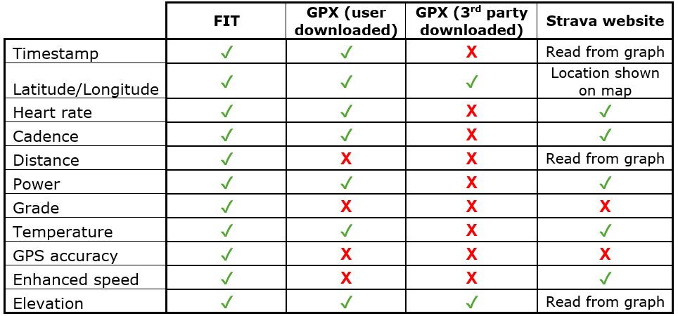
The FIT file contained data including timestamps, latitude and longitude, heart rate, distance and speed. The timestamps showed that around the time of the collision there was a gap of seven seconds in the recording, followed by a further period of 13 seconds during which no data was recorded. The rider logged into their Strava account and downloaded the GPX file from the website. This file contained less information than the FIT file and, for example, did not include recorded distance or speed data. A third party also viewed the rider’s Strava profile and downloaded the GPX file from the website. However, the file available to the third party contained even less information, likely because of privacy settings. It did not include timestamps, which meant speed could not be calculated. Only positional information (latitude, longitude and elevation) was available.
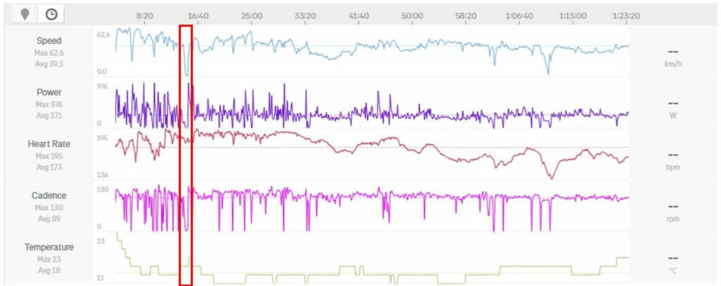
The Strava website displays information about the ride in the Analysis section through a series of graphs and a map. The graphs can be viewed by elapsed time or distance, and the values are shown on the right-hand side as the cursor moves along the graph. Figure 1 shows the data recorded across the entire ride, with the collision occurring within the annotated red box.
It is possible to select part of the activity by highlighting an area on the graph and zooming in to an area of interest. Figure 2 shows the speed trace against elapsed time around the time of the collision, as displayed on the Strava website in blue. The speed and time data taken from the FIT file has been overlaid in red. This illustrates the difference between the FIT file data and the smoothed data displayed on the Strava website. The FIT file contains no information during the seven and 13-second periods when the cycle computer was not recording, as shown by the gaps in the red line. By contrast, the Strava graph fills these gaps and displays a continuous line.

Table 1 provides an overview of the data contained in each of the downloaded files and on the Strava website.
The case study highlights the importance of providing experts with the most accurate data. Whilst the provision of any data from the parties involved in litigation is helpful, it is incumbent upon experts to assess the best evidence obtainable.
It must be recognised that GPS devices are not designed as collision sensors. While they can provide substantial information about the circumstances leading up to a collision, they cannot identify the precise point or mechanics of impact in the way a dedicated crash telematics device can. They often record at a rate of 1 Hz (1 data point per second) whereas devices designed for recording collision data would record at much higher rates, potentially as high as 100 hertz (100 data points per second) or more. The positional accuracy of GPS data is device-dependent and may be affected by factors such as dense tree cover, tall buildings, bridges, tunnels or electrical interference. When used alongside wider evidence relating to the collision, such as photographs, scene marks, and post-impact positions of the vehicles or persons involved, GPS data can be interpreted in a balanced and reliable way.
Evidential Hierarchy in Practice
From a forensic standpoint, GPS-related evidence can be ranked as follows:
- FIT (Original File)
Highest evidential value; a complete, unprocessed dataset suitable for detailed reconstruction. If the cycle computer or mobile phone is available, data may be downloaded directly rather than through an app. - GPX Export
Moderate evidential value; useful for route analysis, but limited in precision. A user may also have access to more data when downloading a GPX file from their own Strava account than a third party can access. - Website based Activity Display
Lowest evidential value; interpretative and not always suitable for quantitative reconstruction, although it may provide a more representative indication of cyclist or runner speed than reliance on published average-speed data alone.
Conclusion
The widespread use of Strava and similar platforms has made GPS data increasingly accessible in collision investigations. However, accessibility should not be mistaken for evidential reliability.
The key distinction lies in data fidelity:
- The Strava interface presents an interpreted narrative
- GPX exports provide a simplified dataset
- FIT files preserve the original recorded data
For robust collision reconstruction, reliance on the original FIT file is essential. Anything less introduces uncertainty through smoothing, recalculation or data loss, each of which may materially affect conclusions in both civil and criminal contexts. When considered alongside the physical evidence from the collision, the data can be used more robustly.
For insurers and lawyers dealing with such cases it is advisable to request the involved parties obtain both the FIT and GPX files from their online account. Depending on the platform, export options may not be clear, and if that is the case it is worth seeking early advice from experts with specific experience in processing and analysing this data. It is always helpful to seek this advice as soon as possible as the device itself may also contain useful data.
About The Authors
Siobhan O’Connell is a forensic collision investigator specialising in the reconstruction of serious and fatal road traffic collisions. She holds a First-Class Master’s (Hons) degree in Medical Engineering from the University of Surrey and has practical investigative experience from her time with Hampshire and the Isle of Wight Constabulary, complemented by road safety research undertaken whilst working at the Transport Research Laboratory. Her expertise includes collision reconstruction, CCTV analysis, Advanced Driver Assistance Systems (ADAS), and injury biomechanics. She has prepared evidential reports and provided expert evidence in Coroner’s Court and the Crown Court.
Steven Mairs is a Chartered Engineer and Member of the Institution of Mechanical Engineers with a First-Class Master’s (Hons) degree in Mechanical Engineering from Queen’s University Belfast. He has extensive experience as a collision investigator, specialising in the forensic reconstruction of road traffic collisions. His expertise includes scene examination, vehicle and component analysis, and interpretation of digital evidence such as CCTV, tachograph data, and event data recorders. Steven is a registered Bosch Crash Data Retrieval analyst and has acted as an expert witness in Magistrates’ and Crown Courts and at Coroners’ Inquests.
References
Garmin (n.d.) FIT SDK Overview. Available at: https://developer.garmin.com/fit/overview/
Strava (2026a) How Distance is Calculated. Available at: https://support.strava.com/hc/en-us/articles/216919487-How-Distance-is-Calculated
Strava (2026b) Exporting your Data and Bulk Export. Available at: https://support.strava.com/hc/en-us/articles/216918437-Exporting-your-Data-and-Bulk-Export